
Comparing AI and Meteorologist Predictions for the December 2nd Snow Event
- NJWxNews

- Dec 3, 2025
- 3 min read

New Jersey's first snow event of the season has now passed and it's time to see how Artificial Intelligence (AI) stacked up against the professionals.
The Professionals
I picked out the most well known forecasters for the New Jersey region and stacked up their forecasted snow maps against the two AI generated snow maps.


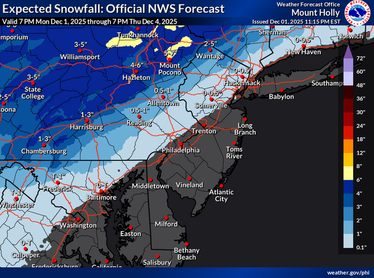
Our selections where; WxRisk, Eastern PA Weather Authority/Weather NJ, NYNJPA Weather, and NWS Philadelphia/Mt.Holly.
NOTE: These maps were posted on X and were saved on December 1st evening before the storm. Not all maps may have been final calls
The overall conesus from the professionals that this snow event would not be a major one but more of a quick hitting mix event that will favor extreme Northwestern NJ and states North and West of New Jersey. All agreed on a mostly rain event for the Southern areas of New Jersey and a mix to rain for Central areas.
The Artificial Intelligence Forecast (Grok & ChatGPT 5.1)


ChatGPT 5.1 (Left Image) and Grok (Right Image) both came out with the identical forecasts. You can read their AI forecast here. I had to use QGIS software to properly make a snow map for their prediction as they both were extremely awful on making their own snow map using correct NJ county boundaires and county names. However, both were able to write the proper code to transfer their forecast to the QGIS software.
The AI's consensus was very similiar to the professionals with the higher snow totals further North and West and more rain the further South in the state. Based off their outputs on their forecast, Grok went more in detail regarding the weather setup and laying out probabilties for different scenarios. ChatGPT 5.1 was more to the point with a quick summary of how it believed the snow event will play-out without referencing any model data or observations on why it made those decisions.
National Weather Service Observed Snow Totals

The observed totals is shown from 10:23pm on December 2nd with the highest reported to the National Weather Service of 3.6". All the observed snow totals were located in the Northwestern sector of New Jersey, precisely where the professionals and the AI forecasted.
I can assume, the large area of Central and South New Jersey with no observed totals were due to the event being mostly rain with no measurable accumulation, which is exactly what the general consensus of both professionals and AI forecasted to happen.
Verdict
In my personal opinion, the professionals documented and cleary communicated the overall event very well and were in-line with their projected forecasted amounts compared to the observered totals. The AI forecasts also clearly demonstrated the biggest measurable snowfall threat was to the Northwest regions of the state and getting less probable as you go further Southeast.
As the first test and the first snow event of the season, this was an excellent start to the expirement and I am looking forward to seeing if AI can compete with professional meteorlogist the rest of the Winter. I do not think AI can replace the human elemement but I believe it can be a very helpful tool when making forecasts, espcially when time is a factor. I am not sure how much time and effort went into the professionals forecasts but both AI systems made a forecast and a snow map in minutes with minimal effort and was able to produce similar results as the professionals.
In upcoming testing, I would like to see how it handles potential snow threats days in advanced and identifying setups with early projections. This first test was only done 24hrs in-advanced while the professionals were tracking and making early predictions much earlier.


Comments